
Even
though we feel disorganized all the time here on Earth, NASA is still there to
give us, the earthlings, a wonderful view of the cosmos with billions of lights
up in the sky.
A brand
new image collection of Jupiter was recently released by The National
Aeronautics and Space Administration (NASA). The striking stormy southern
hemisphere of Jupiter exists 484 million miles far from the Earth.
The Juno
spacecraft had been taking the images of Jupiter since its first close trip by
the planet in 2016. Juno had been sending important images and stunning pictures
of Jupiter since then.
1#

NASA –
The Juno spacecraft of NASA is a bit more than one Earth diameter from Jupiter
when it captured this color-enhanced sight of the tumultuous atmosphere of the
planet.
2#

NASA – These
are some of the swirling clouds of the North Temperate Belt of Jupiter. The
images show several bright-white “pop-up” clouds plus an anticyclonic storm,
called the white oval.
3#

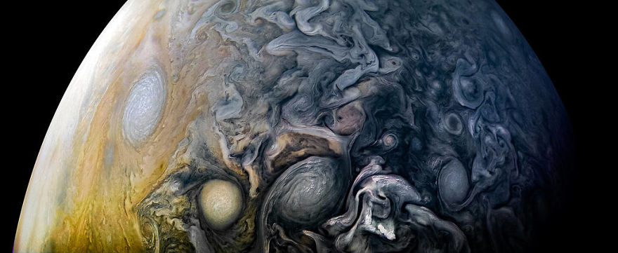
NASA – Here,
in this image, you can see some swirling formations of clouds around the south
pole of Jupiter. These clouds stretched up towards the equator.
4#

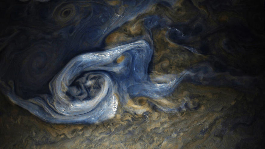
NASA – Here
are the Jovian clouds in stunning blue shades in the new pic taken by the Juno
spacecraft.
5#

NASA – The
Juno spacecraft successfully captured this while it was on its 24th close flyby
of Jupiter. This shows a chaotic, stormy region of the northern hemisphere of
Jupiter. This region is also known as the folded filamentary region. There
isn’t a solid surface like the Earth. Also, some of the research studies
indicate that the winds of the giant planet last longer and run deeper than the
same atmospheric conditions on the Earth.
6#

NASA – In
this image, the active moon lo of Jupiter casts its shadow on it. One could
witness a total solar eclipse within the dark circle racing across the cloud
tops of Jupiter while it passes by the Sun.
7#

NASA – This
was captured when the Juno craft was at the tumultuous northern regions of the
planet on Feb. 17, 2020.
8#

NASA – This
stunning view of the southern hemisphere and the Great Red Spot of Jupiter was
captured during a closer passage.
9#

NASA – This
picture was captured whilst the recent flyby of the gas planet on Dec. 21,
2018.
10#

NASA – The
equatorial zone of the planet is quite obviously shown in this specific JunoCam
image. The interpretation of the infrared measurements of water is made
complicated by these clouds. These clouds are transparent and allow the
Microwave Radiometer of the Juno craft to measure their water into the
atmosphere. This image was acquired on the 16th of Dec 2017.
11#

NASA – This
photograph shows the tumultuous vortices and the swirling cloud belts of the northern
hemisphere of Jupiter.
12#

NASA – This
is the view of the south pole from an altitude of 32,000 miles (52,000
kilometers). The oval-shaped things are the cyclones, up to 600 miles (1,000
kilometers) in diameter. This is a color-enhanced and stereographically
projected combination of three images that showed three separate orbits of
Jupiter in daylight.
13#

NASA – The
spacecraft shot this photo within a Jovian jet stream showing a Vortec with an
extremely dark center. Except that, you can also witness some high, bright
clouds that have puffed up into the sunlight.
14#

NASA – This
is another picture that shows intricate, colorful designs of the jet stream
known as "Jet N3" of the northern hemisphere of Jupiter.
15#

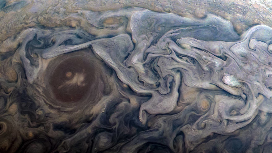
NASA – This
image shows the surrounding turbulent zones of the Red Spot of Jupiter.
16#

NASA – This
Jovian cloudscape is dominated by the southern edge of the northern polar
region of Jupiter.
17#

NASA – This
picture of the swirling south polar region of Jupiter was captured by the
Junocraft while it was in a near flyby.
18#

NASA – The
swirling cloud belts full of colors dominate the southern hemisphere of
Jupiter.
19#

NASA – This
is a detailed photo in which you can see one of the eight massive rotating
storms of Jupiter. This is one among the white ovals in the “String of
Pearls''. The speed of rotation of these storms is quite high and these rotate
at 40 degrees south latitude.
20#

NASA – This
particular site shows the remarkable incident of the merging of two storms.
21#
NASA – This
is a color-enhanced picture of a huge raging storm in Jupiter. This was
successfully captured during the ninth close flyby of the Juno craft.
22#
NASA – How
do you feel about the intricate cloud patterns of the northern hemisphere of
Jupiter?
23#
NASA – These
are the dramatic features of Jupiter's atmosphere. The newest perspective shows
the swirling clouds that gather around a circular feature within a jet stream
region known as “Jet N6.”
24#

NASA – This
specific image shows the intense vortices and the jets of the Northern
temperate belt.
25#

NASA – This
was acquired by the spacecraft on the 19th of May, 2017 at an altitude of 7,990
miles (12,858 kilometers). The small bright clouds dominate the entire south
tropical zone of Jupiter. Yet the cloud towers up to 30 miles (50 kilometers)
in width and 30 miles (50 kilometers) in height. The clouds of this much of the
height in Jupiter are normally composed of ammonia ice and water. Perhaps,
these can be the sources of lightning too. This is the first time to see such a
large gathering of cloud towers, possibly because of the late-afternoon
lighting.
26#

NASA – This
is another successful mission of the colorful swirling clouds in Jupiter’s
North Equatorial Belt.
27#

NASA – This
is another extraordinary picture of Jupiter that was captured on the 17th of
February 2020. It is one of the most remarkable closest approaches to the gas
giant.
28#

NASA – The
Juno craft succeeded in another attempt at capturing the outbound leg of its
12th close flyby of the gas giant.
29#

NASA – Do
you witness the amazing swirling cloud formations in the northern area of the
north temperate belt of the gas giant?
30#
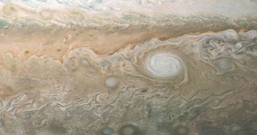
NASA – The final image shows you an unexpected white oval cloud in the South temperate belt. It is named the White Oval A5 and it features an anticyclonic storm. Perhaps the term anticyclone is something new to you! Anticyclonic weather means a weather phenomenon in which the surrounding winds flow in the direction opposite to those flow to the area with low pressure.
Post a Comment