
As part
of its new
time lapse feature, Google Earth posted a series of videos over on YouTube
demonstrating how dramatically our world's oceans, forests, glaciers, beaches,
and cities have changed from 1984 to 2020.
Take a
look at how human activities and natural forces have influenced the Earth
below. The links to the original videos are located beneath each photo in this
list. Remember, it is up to us to stop climate change. Even though the four
decades of audiovisual pictures we've seen make things appear bleak, there is
still hope.
Natalie M. Mahowald, an American Earth
scientist and the Irving Porter Church Professor of Engineering at Cornell
University, said that climate and environmental change have such a gradual
influence that it's difficult to notice.
"Seeing
the shift from either land-use conversion or climate change in one 30 second
video may help humans grasp the vast geographical scale of all the changes that
are occurring," Professor Mahowald
explained about Google Earth's new time lapse function.
#1 Mato
Grosso, Brazil. Image
credits: Google Earth #2
Columbia Glacier, Alaska, USA.
Image
credits: Google Earth #3 Aral
Sea, Kazakhstan.
Image
credits: Google Earth Considering
overwhelming scientific evidence that climate change is extremely real, there
are many skeptics. According to Mahowald, the facts no longer matter.
"Unfortunately, climate change has become politicized to the point where
science is no longer relevant," she said. However,
there have been some encouraging developments in the battle against climate
change. "The revolution in renewable solutions like wind and solar have
made it feasible to transform our energy systems to considerably less
carbon-intensive solutions," Mahowald said, emphasizing that renewable
energy technology is advancing in a favorable direction. "This makes it
more probable that we will maintain temperatures below 3 degrees Celsius, which
is far better than I would have predicted five years ago. With a few more
rotations like that, we should be able to maintain temperatures even
lower!" #4 Nuflo De Chavez, Bolivia.
Image
credits: Google Earth #5 Shanghai, China.
Image
credits: Google Earth #6 Newfoundland And Labrador, Canada.
Image
credits: Google Earth Other frots aren't all doom and gloom,
though. Despite the fact that over half of the world's forests have been
destroyed or degraded for human use, the rate of deforestation has dropped. Deforestation averaged about 10 million
hectares per year between 2015 and 2020, down from 16 million hectares per year
in the 1990s. This does not change the reality that trees are being felled at
an alarming rate; nevertheless, the rate has substantially decreased. It is up
to us whether this trend continues. The message that Google is conveying to
everyone is clear: humans are having a significant influence on the environment
(and the best way to see the evidence for yourself is with its new time-lapse
tool). #7 Atsimo-Andrefana, Madagascar.
Image
credits: Google Earth #8 Dubai, Uae.
Image
credits: Google Earth #9 Mylius-Erichsen Land, Greenland.
Image
credits: Google Earth Google collaborated on the time lapse
project with many government institutions including NASA, the US Geological
Survey, and the European Space Agency (as well as the European Union itself!). According to Forbes, the time lapse function makes
use of about 24 million satellite pictures acquired by Google Earth from these
organizations to demonstrate how nature has evolved. Meanwhile, Carnegie Mellon University
assisted in the development of the time lapse technology. The 20 petabytes of
footage required over 2 million processing hours to generate the 4.4 terapixel
zoomable video mosaic of Planet Earth. Which is a sophisticated and technical
way of stating that the project required a significant amount of effort. Keep
that in mind when you use the tool. According to climate scientist Mahowald, the time lapse project is
"wonderful" and will help people comprehend climate change and its
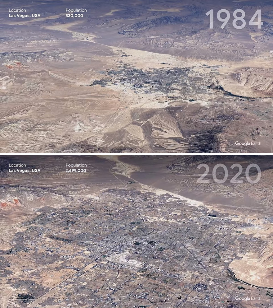
impact on our ecosystem in a more concrete way. #10 Las
Vegas, USA.
Image
credits: Google Earth #11 Sara, Bolivia.
Image
credits: Google Earth #12 Enright, Oregon, USA.
Image
credits: Google Earth “Because of the large temporal and
spatial dimensions, it is extremely difficult to persuade people to comprehend
the extent of climate change and the land-use problem. I wouldn't be shocked if
this one piece of software changed many people's thoughts about the magnitude
of human effect on the environment,” Cornell University's Mahowald added. However, Google's goals are not over. The
firm has claimed that we would all be able to view time lapse presentations of
pretty much any location that we choose. #13 Pearl
River Delta, China.
Image
credits: Google Earth #14 Mamore River, Bolivia.
Image
credits: Google Earth #15 Singapore.
Image
credits: Google Earth Take a look at the tool and the movies,
play about with them, and let us know what you think, dear Readers. Do you
believe it will assist raise awareness of climate change? Please share your
thoughts in the comments area.
#16 Chatham, Massachusetts.
Image
credits: Google Earth


Post a Comment